Cairo Top Tours
Cairo Top Tours

Latest Articles

  • Egypt Aswan Governorate Aswan

    Aswan Governerate in Egypt

    One of Egypt's southern governorates is Aswan Governorate. The city of Aswan serves as its capital. At a latitude of 22 north of the equator (also known as the Tropic of Cancer), it is bounded to the north by the Qena Governorate, to the east by the Red Sea Governorate, to the west by the New Valley Governorate, and to the south by the Republic of Sudan.

  • Things to Do in Luxor

    Luxor Governorate Egypt

    The capital of the Arab Republic of Egypt is Luxor City, which was once known as "Thebes City" because it served as Egypt's capital during the Pharaonic era. It is situated in the South Upper Egypt region, approximately 670 kilometers from the capital Cairo from the south. It is bordered on the north by Qena Governorate, on the south by Aswan Governorate, on the east by Red Sea Governorate, and on the west by New Valley Governorate.

  • kafr El Sheikh Governorate | kafr El Sheikh Governorate History

    History of kafr El Sheikh Governorate

    Kafr El Sheikh Governorate is an Egyptian governorate, located in the northernmost part of Egypt in the Nile Delta, with Kafr El Sheikh as its capital. It had a population of 3,172,753 in 2015 and an area of 3,748 km². Its entire area is located north of the delta and overlooks the Mediterranean Sea. The main economic activity of the residents of the governorate is agriculture and fishing, especially the southern lands of the governorate and the lands overlooking the Nile River - Rosetta Branch.

  • Egypt's New Administrative Capital City

    Egypt's New Administrative Capital

    The New Administrative Capital is located between the Cairo-Suez and Cairo-Ain Sokhna roads, 60 km from Cairo and the same distance from Ain Sokhna and Suez. The New Administrative Capital is located on the border of Badr City, in the area between the Cairo-Suez and Cairo-Ain Sokhna roads, just after New Cairo, Mostakbal City and Madinaty.

  • Historical Importance of Al Gharbia

    Al Gharbia Governorate

    Gharbia Governorate is one of the governorates full of archaeological sites, whether they are places or facilities (mosques, churches), as the governorate is a destination for visitors to these places throughout the year, whether they are Egyptians from the different governorates.

  • Marsa Alam City

    Hamata Islands (Qulaan Archipelago) in Marsa Alam

    The Hamata area, south of Marsa Alam in the Red Sea, is one of the most important parts of the Wadi El Gemal Reserve, whether in the desert or the sea. It was named after the sorrel plant, which was distorted to Hamata.

The Roda Nilometer in Cairo

Facts about The Roda Nilometer in Cairo

  • 05 16, 2023

Facts about The Roda Nilometer in Cairo

The Nile gauge at the southern end of Rawda Island in Cairo, Egypt. It was used to measure the flooding of the Nile, to determine taxes for the next agricultural year, and to prepare for the Nile Feast.

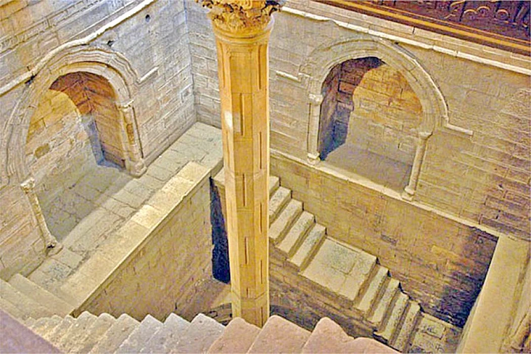
The Nile gauge was renovated in 247 AH - 861 AD by order of the Abbasid Caliph Al-Mutawakkil in Fustat (Al-Rawda Island). The lower floor is circular in shape, topped by a square wall whose side length is greater than the diameter of the circle, and above it is the upper square whose side length is longer than the side length of the middle square.

The well of the gauge was built of carved stone, and inside it there is a large, deep basin to which a marble staircase descends on the circle, and in the center of the basin is a standing marble column, with drawings, numbers, arms and pigments, and on top of the column is a numbered building made of stone, which is colored and painted with gold, lapis lazuli and all kinds of elaborate pigments.

Some of the inscriptions and marble coverings of the gauge have been lost as a result of the restoration of the gauge. On the basis of the Nile gauge, tribute was collected and prices of goods were determined. The Nile water entered the gauge through a hole in the wall of the gauge, and the water level was determined.

The Nile gauge in Rawda is one of the Abbasid constructions, and Egyptians have known since ancient times to build gauges throughout the country to recognize the height of the Nile due to its close relationship with land irrigation and the collection of revenue. Arabic sources refer to many of the gauges that were established in Egypt after the Arab conquest, including: Muawiya bin Abi Sufyan( 41-60 e): Anasna scale .

Abdulaziz bin Marwan: Established a scale in Helwan in 80 H. Osama ibn Zayd al-Tanufi, the Kharaj factor, built a gauge in Rawda during the reign of al-Walid ibn Abdulmalik (86-96 H) in 92 H. Suleiman ibn Abdulmalik canceled its work and built another one in 97 H, five years later. In 247 H, Caliph al-Mutawakkil (232-248 H) ordered the construction of the gauge.

Tags:
Share On Social Media:

Egypt Tours FAQ

Read top Egypt tours FAQs

To predict the size of the crops from year to year, the ancient Egyptians built a series of wells called Nilornetri, one of which is still visible, carved in the rocks of the island of Roda.

A long time ago, people in Egypt used a special tool called a nilometer to figure out how much food they could grow and how much money they needed to give to the government. Recently, scientists found one of these special tools in the old city of Thmuis in Egypt.

Yes, visitors can access the Roda Nilometer and explore its chambers and measurement shaft. The site is open to the public, allowing visitors to learn about the history and significance of this ancient hydraulic structure.

;

Cairo Top Tours Partners

Check out our partners

EgyptAir
Fairmont
Sonesta
the oberoi